Park nearby César Díaz Park
Uruguay
Park nearby César Díaz Park
César Díaz Park
Gral. José Villagrán, José Antonio Cabrera y, 20 de Febrero, Montevideo Uruguay
contacts phone
:
+598
Latitude:
-34.8696854
, Longitude:
-56.1320113
read more
nearest Park
Parque César Díaz
Gral. José Villagrán, José Antonio Cabrera y, 20 de Febrero, Montevideo
Park
read more
56 m
Skatepark Plaza 5
Montevideo
Park
read more
914 m
Plaza de la Restauración
Montevideo
Park
read more
1.116 km
deposito
Pres. Ingeniero José Serrato 2821, Montevideo
Park
read more
1.372 km
La Bombonera
Montevideo
Park
read more
1.568 km
Intercambiador Belloni
Avenida José Belloni, Montevideo
Park
read more
1.67 km
Plazoleta
Camino Corrales 3029, Montevideo
Park
read more
1.674 km
Plaza del Parque Guaraní
Montevideo
Park
read more
1.718 km
Plazuela Leon Duarte
Montevideo
Park
read more
1.764 km
Complejo DANUBIO DEL CAMPO
Doctor Roberto Berro 2356, Montevideo
Park
read more
1.766 km
Club Baby Fútbol Parque Guaraní
Itapeby, Montevideo
Park
read more
1.912 km
Patio Faculty of Science
Montevideo
Park
read more
1.912 km
Patio Facultad De Ciencias
Montevideo
Park
read more
1.925 km
Plaza De La Aviación Nacional
Avenida Dámaso Antonio Larrañaga 4101, Montevideo
Park
read more
1.925 km
Plaza Mateo Vidal
Ignacio Núñez, Montevideo
Park
read more
1.947 km
Espacio Libre Atilio Rapat
Avenida Italia 3776, Montevideo
Park
read more
1.995 km
Parque Antel Arena
Avenida Dámaso Antonio Larrañaga 4101, Montevideo
Park
read more
2.04 km
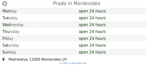
Prado
Madreselva, Montevideo
Park
read more
2.047 km
Espacio libre Luis Touron
Montevideo
Park
read more
2.175 km
Jardin Del Parque - Vivero
entre Ignacio Nuñez y Nievas, Avenida Italia 3297, Montevideo
Park
read more
2.42 km
Parque De La Juventud
Montevideo
Park
read more
2.42 km
Juventud Park
Montevideo
Park
read more
2.743 km
Espacio Libre Yuri Gagarin
Montevideo
Park
read more
3.165 km
Plazoleta Leonel Viera
&, Avenida Ramón Anador, Montevideo
Park
read more
3.336 km
Plaza Guernica
Montevideo
Park
read more
📑
all categories
Accounting
Administrative area level 1
Administrative area level 2
Airport
Amusement park
Aquarium
Art gallery
Atm
Bakery
Bank
Bar
Beauty salon
Bicycle store
Book store
Bowling alley
Bus station
Cafe
Campground
Car dealer
Car rental
Car repair
Car wash
Casino
Cemetery
Church
City hall
Clothing store
Colloquial area
Convenience store
Courthouse
Dentist
Department store
Doctor
Electrician
Electronics store
Embassy
Finance
Fire station
Florist
Food
Funeral home
Furniture store
Gas station
General contractor
Grocery or supermarket
Gym
Hair care
Hardware store
Health
Hindu Temple
Home goods store
Hospital
Insurance agency
Intersection
Jewelry store
Laundry
Lawyer
Library
Liquor store
Local government office
Locality
Locksmith
Lodging
Meal delivery
Meal takeaway
Mosque
Movie rental
Movie theater
Moving company
Museum
Natural feature
Neighborhood
Night club
Painter
Park
Parking
Pet store
Pharmacy
Physiotherapist
Place of worship
Plumber
Point of interest
Police
Political
Post office
Premise
Real estate agency
Restaurant
Roofing contractor
Route
Rv park, camping
School
Shoe store
Shopping mall
Spa
Stadium
Storage
Store
Subpremise
Supermarket
Synagogue
Taxi stand
Train station
Transit station
Travel agency
University
Veterinary care
Zoo
administrative area level 4
sublocality level 1
↑